Monday, 31 October 2011

Deforestation and Climate Change

   
According to the IPCC’s Fourth Assessment Report (2007) the share of the forestry sector (including deforestation) in overall global emissions in 2004 was 17.4%. This was higher than emissions from the entire transportation sector (13.1%) the same year. The forestry sector in 2004 was the third highest emitting sector after energy supply (25.9%) and industry (19.4%). The reason deforestation increases atmospheric greenhouse gas (GHG) concentrations is that the burning or decay of forests release the carbon stored in trees and the soil.  

According to Schenider et al (2006), tropical deforestation can also influence the global tropics by enhancing El Niño / Southern Oscillation (ENSO) variability. Diagnostic experiments indicate that changes in land surface properties cause changes in the mean surface wind stress in the tropical Pacific, which destabilizes the ENSO system leading to increased variability.  

While deforestation and forest degradation emit GHGs, through afforestation (new plantings), reforestation (replanting deforested areas) and sustainable management forests can play a significant role in climate change mitigation. Forests can act as carbon sinks by fixing carbon dioxide (CO2) from the atmosphere. Trees are generally 20% carbon by weight and organic matter in forest soils also store large amounts of carbon. According to the latest FAO/ITTO report, tropical rainforests store an estimated 652 gigatonnes (Gt) of carbon in their biomass, 42% of which is found in the three rainforest basins.

Tropical rainforest in Puerto Rico (source: Britannica online)

Friday, 28 October 2011

Wednesday, 26 October 2011

Globalization and the great forest transition

 
The majority of social scientists accept the notion of “forest transition” (also known as “the environmental Kuznets curve”), which describes a historical pattern of change in forest area where as societies industrialize and urbanize, forests first decrease and then grow in extent.

Thomas K. Rudel in ‘
Paths of Destruction and Regeneration: Globalization and Forests in the Tropics’ investigates why the relationship between globalization and tropical forests is so that globalization depletes ‘First Nature’ and fosters ‘Second Nature’, where ‘first nature’ refers to old-growth or primary forests while ‘second nature’ refers to forests regenerated after human disturbance.

How globalization depletes “First Nature”?

Rudel explains that engagement in international trade in tropical forest commodities induces entrepreneurs to invest in large-scale infrastructural projects, something local traders can hardly ever afford. As commercial loggers move through an area they take commercially valuable trees from primary forests, leaving these forests highly degraded. Infrastructural development also makes primary forests accessible for smallholders who clear land for agriculture. The initial high nutrient content of deforested land is, however, quickly depleted, forcing farmers to move further into the forest. Finally, Rudel notes, market expansion creates geographical flow of labor to the frontier seeking work at newly created enterprises.
 

How globalization fosters “Second Nature”?
According to Rudel’s analysis, continuing market expansion into new areas increases pressure on producers in older production zones. In many cases farms of older zones do not survive the competition from farmers of newly deforested – and therefore still highly fertile – areas. When producers leave these failing farms ‘Second Nature’ quickly takes hold on these abandoned lands.

While secondary forests store considerably less carbon than primary forests (for at least 200 years of age) they still provide some environmental benefits of primary forests as well as some forest products local and indigenous people used to obtain from primary forests and thus their management and protection should not be neglected.
  

Tuesday, 25 October 2011

Of Forests and Men (Official Film for the International Year of Forests)

Monday, 24 October 2011

Scientists join forest loggers in massive ecology experiment

  
Ecologists from Imperial College London have joined forest loggers of the Malaysian state-owned company the Malaysia Sabah Foundation to conduct the world’s biggest ecological experiment to date, the New Scientist reports. As the company has a massive deforestation program going ahead anyway - felling 75,000 hectares of rainforest on the island of Borneo and converting it to lucrative palm oil plantation - the Imperial College team decided to exploit it to examine the ecological effects of large-scale habitat fragmentation. The aim of the experiment is to gain insight on how to design landscapes to support multiple demands (both ecological and commercial) at a minimal cost to the ecosystem.

Click here
to read the article on the New Scientist website.

Friday, 21 October 2011

What drives deforestation in the Amazon Basin?

  
There is a general agreement in the literature that cattle ranching and agricultural expansion for crop production are the biggest drivers of deforestation in the Amazon Basin. In a 2007 article for the Ecologist, Diego Martino (Senior Analyst at the Latin American Centre for Social Ecology) empathizes the importance of cattle ranching in the Brazilian Amazon where, Martino points out, there is six hectares of pasture for each hectare of agriculture. In Peru the ratio is two to one. These numbers are driven by the high economic return for cattle ranching in the region. Regarding agricultural expansion for crop production, Martino notes that between 1970 and 2002 more than 1,300 settlements were created in the Amazon region, occupying 230,000 square kilometers of land. Deforestation around these settlements is four times higher than in other parts of the Amazon. Martino states that contrary to some reports soy producing monocultures are not significant direct drivers of deforestation, as they are found mostly south of the Amazon, however play an important indirect role by pushing small landholders and cattle ranchers northwards into the rainforest. In July 2009 Brazil (the world’s largest soy exporter) agreed not to trade soy from deforested land, although, as the Treehugger reports this policy “doesn't prevent farmers from planting soy and selling it illegally on the spot market”. Nonetheless, the policy still prevents the spread of soy farms into large areas of deforested land. The main driver behind the expansion of soy monocultures is demand from China and European feedlots, and more recently demand for soy and other cash crops for biofuel production. In the Peruvian Amazon, as well as in Bolivia and Columbia, coca crops occupy large areas of deforested land. Coca crops are thought to be responsible for up to 24% of deforestation in the Peruvian Amazon.

In addition to cattle ranching and agricultural expansion Martino names road development as an important direct as well as indirect driver of deforestation in the Amazon Basin by constituting the opening act in the deforestation process and making previously inaccessible rainforest areas open for logging. According to a report by
Kirby et al (2007), 80% of deforestation in the Amazon is taking place less than 30 km away from an official road.

For further details on the development of cattle ranching in the Brazilian Amazon I recommend the article ‘Ranching and the new global range: Amazônia in the 21st century’ from Walker et al (2008), which gives a great overview of the policy environment in which Brazil – a country previously thought unsuitable for agricultural development – has become a dynamic cattle economy. 


Photo: Leonardo F. Freitas via flickr (from Treehugger)

Thursday, 20 October 2011

Changing Forests - Interactive Map

   
To accompany its article 'With Deaths of Forests, a Loss of Key Climate Protectors' (October 1, 2011), the New York Times published an interactive map illustrating the history of forest loss across the world. The map shows current forest cover, recent losses (between 2000 and 2005) and estimated extent of ancient forests (forest cover 8000 years ago) on different continents.

Changing Forests - Interactive Map (New York Times)

Tuesday, 18 October 2011

Amazonia as a “manufactured landscape”?

 
Views on Amazonia as an untouched, virgin ecosystem have gradually changed with the exploration of archeological sites and the emergence of records of long-term human occupation. However, Bush and Silman in their article ‘Amazonian exploitation revisited: ecological assymetry and the policy pendulum’ (2007) warn that the popular new paradigm of Amazonia as a “manufactured landscape” should be used with caution as it has important implications on conservation and policy approaches.

Bush and Silman writes that the size of indigenous human population at the time of European arrival is estimated around 11 million, which gradually but drastically declined following contact with Europeans. Archeological findings prove that some sites in the region were occupied for several thousand years. The paper cites Balée (1989) who estimates that up to 11% of Amazonian vegetation was used and altered by pre-Columbian occupants. Evidence of human occupation can be obtained from pollen, charcoal and phytolith data, all of which, in case of the Amazon region, indicate widespread human occupation prior to European contact. There are, however, differing views regarding the extent to which these indigenous inhabitants modified their environment. The analysis of Bush and Silman concludes that while some areas with extensive settlements – mostly around main river channels and highly seasonal areas – were altered by pre-Columbian occupants, influences on ecosystems were very local and most of Amazonia was minimally impacted.

In addition, Bush et al. (2007) points out, it can be challenging to determine whether past ecosystem changes in Amazonia were due to direct human influence (e.g. direct deforestation), indirect human influence (e.g. introduction of diseases), natural causes (such as drought), or a combination of these.

Understanding the history of human disturbance in the Amazon region can not only aid effective conservation and policy making but, as Bush and Silman (2007) notes, is essential to avoid overestimation of the ‘manufactured landscape’ label as “policy that assumes such resilience may cause substantial and long-lasting ecological damage”.

Monday, 17 October 2011

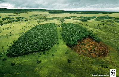
WWF: "Before it's too late"

   
Advertising Agency: TBWA\PARIS, France
Released: April 2008

Friday, 14 October 2011

Is the Amazon dieback scenario realistic?

 
The New York Times blog ‘Green’ published a post last week by Justin Gillis discussing the so-called Amazon dieback scenario. Computer analysis led by Peter M. Cox of the University of Exeter in the UK found that the Amazon rainforest would continue to take up carbon from the atmosphere (and thus act as a carbon sink) until around 2050. However, warmer temperatures and water stress resulting from climate change in the region would eventually cause huge dieback of the Amazon rainforest (which would result in the Amazon forest becoming a carbon source – that is emitting more carbon then it sequesters).

While a number of scientists find Cox’s prediction too pessimistic, the severe droughts of the past decade are indeed worrying. The drought of 2010 is thought to have been even larger then the prolonged drought of 2005 that killed numerous large trees in the region. Two "once a century" droughts in five years… While the triggers of the 2010 drought are still being studied, researchers say that the 2005 drought could have been caused by high Atlantic Ocean temperatures – a possible result of anthropogenic greenhouse gas emissions.

These findings lead Gillis to the logical question: “Could the great dieback predicted for midcentury already be starting?”

While scientists are reluctant to answer this question, there is a general agreement that if the Amazon starts to experience such frequent droughts “all bets are off”.

A field once covered by the forest is prepared for soybean cultivation in Brazil.
(The New York Times, Green Blog)

Thursday, 13 October 2011

State of the World's Forests, 2011


The State of the World’s Forests series, published by the Food and Agriculture Organization (FAO) on a biennial basis, provides up-to-date information on the current state of the world’s forests. 

Under the theme ‘Changing pathways, changing lives: forests as multiple pathways to sustainable development’ the 2011 issue focuses on how forests support people’s livelihoods all around the world. The report is organized around three core subjects – sustainable forest industries, climate change, and local livelihoods – and discusses their potential to stimulate development at all levels.

Tuesday, 11 October 2011

International Year of Forests - FAO video


International Year of Forests, 2011


The United Nations General Assembly declared 2011 as the International Year of Forests to raise awareness on sustainable management, conservation and sustainable development of all types of forests. 

The official website of the International Year of Forests (Forests 2011) contains information regarding events being organized throughout the International Year as well as interactive web tools and resources to promote dialogue on forests.

Saturday, 8 October 2011

Deforestation in Rondônia, western Brazil


The NASA Earth Observatory, through a satellite time series from the Moderate Resolution Imaging Spectroradiometer (MODIS) on NASA’s Terra satellite, has followed deforestation in Rondônia, western Brazil, since 2000. Below are satellite images from 2000 and 2010, where intact forest is deep green, while cleared areas are tan. Images from each year between 2000 and 2010 are available on the
Earth Observatory website.


NASA Earth Observatory, 2000
NASA Earth Observatory, 2010

Vanishing Amazonia


Rainforests play a crucial role in sustaining life on Earth. They provide a fluorishing habitat for 50% of animal and plant species as well as important ecosystem services for humans, regulate temperature and weather patterns, and are critical in maintaining the the planet’s limited supply of drinking and fresh water. The three largest rainforest basins, the Amazon Basin, the Congo Basin, and Southeast Asia have a total forest area of about 1.3 billion hectares (one-third of the total forest area of the planet).

The tropical forests of the Amazon basin, covering 800 million ha and stretching across nine nations of the South American continent, constitute the largest rainforest of the world. Of the three rainforest basins, the Amazon basin suffered the largest net loss in forest area – about 3.6 million hectares annually between 2000 and 2010, mostly to accommodate the expansion of cattle and soybean production. The annual rate of change in forest area in the region was -0.45% between 1990 and 2000 and -0.44% between 2000 and 2010. 62% of the Amazon rainforest is in Brazil and this is where 80% of deforestation in the region has taken place. Although deforestation rates in the country have declined recently, the area of rainforest lost each year is still massive.

Deforestation has many negative effects at local, regional, and even global scales. Forest dependent people lose essential ecosystem services (many of which are also important on regional and global levels), might experience changes in local climate, increase in fire frequency and loss of biodiversity, and may even be displaced from their towns and villages. Large-scale deforestation can also have global impacts, such as changes in precipitation patterns in other parts of the world, although these complex effects are more difficult to predict. 

With current rates of deforestation in the Amazon and the possible devastating effects of climate change on these forest ecosystems some scientists (such as Dr. Philip M. Fearnside of the National Institute for Research in the Amazon and James Alcock from Pennsylvania State University) fear that in a worst-case scenario most of the Amazon rainforest could disappear by the end of the century with unfathomable consequences for the ecological balance of our planet.